I went north on US 395. This is a mainly straight, mainly level, but very spectacular road. This is because for a very long way the road runs close and parallel to Sierra Nevada mountain range which includes Mt Whitney, the highest point in California and the highest peak in the contiguous 48 states (those states excluding Hawaii and Alaska). For a couple of hours, the mountains were my constant companion of my left hand side.
Just north of my stop for the night in Lone Pine, is a place known as Manzanar. This is one of 10 internment camps that were used during the second World War to house Americans of Japanese ancestry. The camps were set up soon after the attack on Pearl Harbor. Over 110,000 were held in this way under what must have been difficult circumstances, both politically and in the summer heat in the 36 blocks that were built on the camp to house the prisoners.
Very little of the original facilities remain at Manzanar except the roads and the foundations of some of the buildings....

Two blocks have been built recently to resemble how the original buildings looked. I think this lookout tower is a reconstruction....

The camp had most of the facilities of a small town, including a farm, a post office, a hospital, warehouses and garage buildings as well as administrative offices. One of the most poignant areas was the cemetery where 150 men, women and children who died at the camp were buried. The highest peak in the background of the first picture is Mt Whitney....


The camp reminded me of the internment that happened in Ireland during the IRA terrorist conflict. People who were suspected of a terrorist crime were placed in internment camps, effectively prisons, despite never having been charged or tried for what they were suspected of having done. Those camps caused enormous bitterness on both sides and I suspect Manzanar had the same impact.
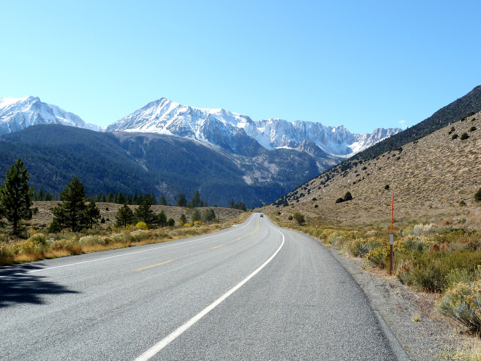
I spotted this old barn further along US 395....

Close by the old barn is a great view of the mountains. I just spotted the view as I was turning my bike around after taking pictures of the barn....

Snow was on most of the high peaks and I discovered this started from about 8200 feet up.... I know because I went up that high twice in the next few days....

US 395 is mainly a 4 lane road, but some stretches are down to two lanes. As the road is mostly straight I got a real sense of getting somewhere fast as I passed the mountains by....
It was lunchtime by the time I got to the turn off point for Yosemite and I wanted to warm up slightly before I started to cross the mountains via Tioga pass. It was suggested to me that I should stop for lunch at a particular place in Lee Vining, but I couldn’t find the suggested restaurant. I went back to the e-mail afterwards and discovered it was located inside a gas station. I should read my e-mails more carefully! Anyway, thanks for the suggestion Randal. I did find somewhere else to eat in Lee Vining and another strange co-incidence happened. The bikes I saw with the Swiss flag stickers on in the car park of the hotel I stayed at in Las Vegas were now parked outside where I had stopped for lunch. I noticed the flags as I looked out of the window, so I chatted to the riders of those bikes over my bowl of warming soup!
Before I left Lee Vining I went to see the nearby Mono Lake. The water in the lake is very salty and has a high alkaline content. Over many years this has created tufa towers that rise out of the water. I didn’t have time to walk to the taller towers, so I was content with looking at the lower sections which have grown near to the road....

I don’t know if it happens all year round, but the lake edge was swarming with thousands if not millions of small flies. They tended to stay on the ground until I walked up to them....

California state road 120, also known as the Tioga Pass is the eastern entry to Yosemite and it had been closed a few days previous due to snow. I had been checking every day with the National Park Service if the pass had re-opened. I was really hoping it had, as the diversion south via Bakersfield is a very long way indeed – something like a 10 hour drive. I was relieved to hear the pass reopened at 5pm on the day before I was due to ride through it, so my luck was holding out and my prayers to the snow clearing Gods seemed to have helped!
I have ridden Tioga Pass before and the first twenty miles or so riding westbound are stunning. Even more so with snow as the back-drop as I rode through. The roads themselves were clear and I was grateful they were. It was very cold on the pass as I climbed to 9945 feet above sea level. It was quite a change from the 192 feet below sea level I had experienced just the day before in Death Valley.
One of the most impressive views occurs some after starting to ride the road. It is almost impossible for any occasional visitor to carry on past this view without stopping with a camera. This is the view looking west....

And this is the view looking east from almost the same place....

Then, I saw this and had to stop again. This is Ellery Lake at 9,538 feet....


Being so cold at this elevation, the melted snow water had soon frozen again....

Another lake next to Tioga Pass....

Soon I saw a stream and I had to stop yet again to take more pictures....


My bike on Tioga Pass....

It was now getting quite late in the afternoon and I still had about 50 miles of some very twisty roads to ride before I would get to my hotel for the night. I needed to keep riding and to forget stopping the bike for photos, or I might be riding in the dark though what would be dangerous roads without the sun to light them. The next 30 miles or so are some terrific riding roads but set amongst trees, so the views are limited and I finally got some serious miles ridden quickly. But, it is difficult to resist the few good view you do see....

I finally arrived at the Wawona Hotel, near the parks southern entrance. It is a historic hotel built in 1876. Many of the rooms have verandas and the overall feeling of the place is very relaxed. There are rooms with private bathrooms and others where two adjacent rooms share a bathroom. The walls of the hotel are very thin indeed. Somebody in the room next to mine snored very loudly. I think it was a woman!

The Wawona Hotel was the first I have stayed at on this tour that didn’t have wi-fi, customers can connect to the internet. I asked why this was and they said as it was a historic hotel, they wanted to keep it as much as possible like it was originally meant to be. I didn’t have the heart to ask why in that case they have digital alarm clocks, electronic smoke alarms, fire extinguishers and electric overhead ceiling fans!
I woke early the morning of day 127 and had a leisurely breakfast and I went for a walk. I was trying to waste some time until the temperature rose to just a little above freezing! I cleared the ice off my bike as other guests got in their cars and drove away, no doubt smiling at the fact they had their nice warm cars to travel in.
It was a fine balance between waiting for the warmth to come and knowing the longer I waited the best morning light would be disappearing and I left it too long. I stopped to get fuel and met Marcel from the Czech Republic. Now living in one of the Carolina’s, he was on vacation and riding a BMW R1200. We talked at the gas station for about half an hour and eventually I left him to fuel his bike as I headed for perhaps the best viewpoint in the park, Glacier Point.
At 7,700 feet high, Glacier Point is not to be missed and it was very cold up there. The 16 mile long ride up is worth it though as the road itself is a motorcycling classic – full of steep gradients and lots of very inviting bends. As I rode along, suddenly Marcel came flashing past me on his BMW.
The views from the top are wonderful....
This is Half-dome.... note the two waterfalls on the right of the picture...

Another shot of Half-dome....

A closer view of Nevada Fall (594 feet) and Vernal Fall (317 feet). Despite them being quite a distance away, the roar of the falls can easily be heard....

From almost the same position on glacier Point, I looked across the main Yosemite Valley at Yosemite Falls....

Here are the Upper and Lower Falls....

Marcel admiring the view....

Marcel’s bike....

Perhaps the most famous view of the Yosemite Valley is taken from Tunnel Overlook....


Yosemite Falls....

The Merced River in the Valley....

The river again, with the spectacular El Capitan rock in the background...

Cathedral Rocks....

Yosemite Falls across the meadow....

What better place could there be for the 19,000 mile point of my tour?....

Without a doubt, Yosemite is a breathtaking place and it deserves to be on my favourite places list!
0 comments:
Post a Comment